


les benedictains

thle
Gebruiker
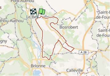

Lengte
13,9 km

Max. hoogte
144 m

Positief hoogteverschil
273 m
Km-Effort
17,6 km

Min. hoogte
48 m

Negatief hoogteverschil
271 m
Boucle
Ja
Datum van aanmaak :
2019-01-15 18:50:49.314
Laatste wijziging :
2019-01-15 18:50:49.314
2h12
Moeilijkheid : Onbekend

Gratisgps-wandelapplicatie
 SityTrail
IGN / Geografische instituten
SityTrail Plus
De wereld gaat voor u open
Over ons
Tocht Paard van 13,9 km beschikbaar op Normandië, Eure, Le Bec-Hellouin. Deze tocht wordt voorgesteld door thle.
Plaatsbepaling
Land:
France
Regio :
Normandië
Departement/Provincie :
Eure
Gemeente :
Le Bec-Hellouin
Locatie:
Unknown
Vertrek:(Dec)
Vertrek:(UTM)
333837 ; 5455542 (31U) N.
Opmerkingen