


181007 EnCours-2

MarcheEtReve
Gebruiker
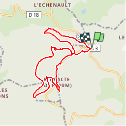

Lengte
9,3 km

Max. hoogte
816 m

Positief hoogteverschil
320 m
Km-Effort
13,5 km

Min. hoogte
584 m

Negatief hoogteverschil
317 m
Boucle
Ja
Datum van aanmaak :
2019-01-15 19:21:14.995
Laatste wijziging :
2019-01-15 19:21:14.995
4h01
Moeilijkheid : Onbekend

Gratisgps-wandelapplicatie
 SityTrail
IGN / Geografische instituten
SityTrail Plus
De wereld gaat voor u open
Over ons
Tocht Stappen van 9,3 km beschikbaar op Bourgondië-Franche-Comté, Saône-et-Loire, Saint-Léger-sous-Beuvray. Deze tocht wordt voorgesteld door MarcheEtReve.
Beschrijving
2e envoi (28 nov)
Foto's


Plaatsbepaling
Land:
France
Regio :
Bourgondië-Franche-Comté
Departement/Provincie :
Saône-et-Loire
Gemeente :
Saint-Léger-sous-Beuvray
Locatie:
Unknown
Vertrek:(Dec)
Vertrek:(UTM)
579829 ; 5198151 (31T) N.
Opmerkingen