


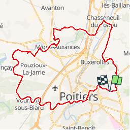
Zevtt - Autour de Poitiers

kipoura
Gebruiker

Lengte
49 km

Max. hoogte
148 m

Positief hoogteverschil
563 m
Km-Effort
57 km

Min. hoogte
64 m

Negatief hoogteverschil
564 m
Boucle
Ja
Datum van aanmaak :
2019-05-03 17:11:37.319
Laatste wijziging :
2019-05-03 17:11:37.438
3h00
Moeilijkheid : Medium

Gratisgps-wandelapplicatie
 SityTrail
IGN / Geografische instituten
SityTrail Plus
De wereld gaat voor u open
Over ons
Tocht Mountainbike van 49 km beschikbaar op Nieuw-Aquitanië, Vienne, Poitiers. Deze tocht wordt voorgesteld door kipoura.
Beschrijving
Une très belle boucle VTT autour de Poitiers ..... http://zevtt.free.fr
Plaatsbepaling
Land:
France
Regio :
Nieuw-Aquitanië
Departement/Provincie :
Vienne
Gemeente :
Poitiers
Locatie:
Unknown
Vertrek:(Dec)
Vertrek:(UTM)
299460 ; 5162340 (31T) N.
Opmerkingen