


Pierrepont (sur les pas des c

phi14
Gebruiker

Lengte
9,2 km

Max. hoogte
46 m

Positief hoogteverschil
108 m
Km-Effort
10,6 km

Min. hoogte
5 m

Negatief hoogteverschil
101 m
Boucle
Ja
Datum van aanmaak :
2019-01-15 19:45:50.086
Laatste wijziging :
2019-01-15 19:45:50.086
2h20
Moeilijkheid : Heel gemakkelijk

Gratisgps-wandelapplicatie
 SityTrail
IGN / Geografische instituten
SityTrail Plus
De wereld gaat voor u open
Over ons
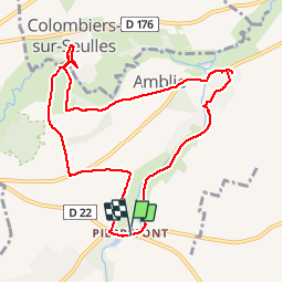
Tocht Stappen van 9,2 km beschikbaar op Normandië, Calvados, Ponts sur Seulles. Deze tocht wordt voorgesteld door phi14.
Beschrijving
Ballade très agréable permettant de découvrir de beaux villages.(sur les pas des carriers).


Plaatsbepaling
Land:
France
Regio :
Normandië
Departement/Provincie :
Calvados
Gemeente :
Ponts sur Seulles
Locatie:
Lantheuil
Vertrek:(Dec)
Vertrek:(UTM)
681661 ; 5461108 (30U) N.
Opmerkingen