


Pic de l'Ours, L'Evêque,lentisques,pic de L'Ours, Col Notre Dame 3544 ET

verotrail
Gebruiker

Lengte
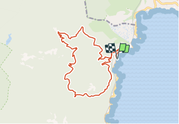
10,2 km

Max. hoogte
486 m

Positief hoogteverschil
485 m
Km-Effort
16,7 km

Min. hoogte
5 m

Negatief hoogteverschil
487 m
Boucle
Ja
Datum van aanmaak :
2019-05-06 10:59:36.543
Laatste wijziging :
2019-05-06 10:59:36.543
3h25
Moeilijkheid : Medium

Gratisgps-wandelapplicatie
 SityTrail
IGN / Geografische instituten
SityTrail Plus
De wereld gaat voor u open
Over ons
Tocht Stappen van 10,2 km beschikbaar op Provence-Alpes-Côte d'Azur, Var, Saint-Raphaël. Deze tocht wordt voorgesteld door verotrail.
Plaatsbepaling
Land:
France
Regio :
Provence-Alpes-Côte d'Azur
Departement/Provincie :
Var
Gemeente :
Saint-Raphaël
Locatie:
Unknown
Vertrek:(Dec)
Vertrek:(UTM)
332071 ; 4815372 (32T) N.
Opmerkingen