


Tachenires - Contranhé

libinsport
Gebruiker
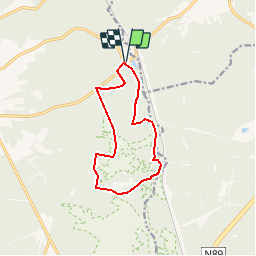

Lengte
9,9 km

Max. hoogte
489 m

Positief hoogteverschil
262 m
Km-Effort
13,4 km

Min. hoogte
373 m

Negatief hoogteverschil
263 m
Boucle
Ja
Datum van aanmaak :
2019-05-06 14:35:29.846
Laatste wijziging :
2019-05-06 14:35:29.846
2h50
Moeilijkheid : Onbekend

Gratisgps-wandelapplicatie
 SityTrail
IGN / Geografische instituten
SityTrail Plus
De wereld gaat voor u open
Over ons
Tocht Stappen van 9,9 km beschikbaar op Wallonië, Luxemburg, Libin. Deze tocht wordt voorgesteld door libinsport.
Beschrijving
15/02/2019
Plaatsbepaling
Land:
Belgium
Regio :
Wallonië
Departement/Provincie :
Luxemburg
Gemeente :
Libin
Locatie:
Libin
Vertrek:(Dec)
Vertrek:(UTM)
666027 ; 5539863 (31U) N.
Opmerkingen
super randonnée