


roucamps18 bis_backup

UDGI54
Gebruiker
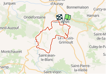

Lengte
25 km

Max. hoogte
353 m

Positief hoogteverschil
450 m
Km-Effort
31 km

Min. hoogte
182 m

Negatief hoogteverschil
447 m
Boucle
Ja
Datum van aanmaak :
2019-05-06 14:53:19.13
Laatste wijziging :
2019-05-06 14:53:19.13
6h35
Moeilijkheid : Medium

Gratisgps-wandelapplicatie
 SityTrail
IGN / Geografische instituten
SityTrail Plus
De wereld gaat voor u open
Over ons
Tocht Stappen van 25 km beschikbaar op Normandië, Calvados, Les Monts d'Aunay. Deze tocht wordt voorgesteld door UDGI54.
Plaatsbepaling
Land:
France
Regio :
Normandië
Departement/Provincie :
Calvados
Gemeente :
Les Monts d'Aunay
Locatie:
Roucamps
Vertrek:(Dec)
Vertrek:(UTM)
674487 ; 5428634 (30U) N.
Opmerkingen
Très belle randonnée.