![](/images/other/stat-length.png)
![Tocht Sneeuwschoenen Angoustrine-Villeneuve-des-Escaldes - Sant Marti d'Envalls - Photo](https://media.geolcdn.com/t/1900/400/ext.pjpeg?maxdim=2&url=https%3A%2F%2Fservices.sitytrail.com%2FGeolivesWS%2FDownloadMedia.ashx%3FTrailID%3D111486%26Media%3D7442_1.jpg)
Sant Marti d'Envalls
tracegps
Gebruiker
![Lengte](/images/other/stat-length.png)
Lengte
9,1 km
![Max. hoogte](https://static1.geolcdn.com/siteimages/upload/files/1508320355ic_sort_altitude_max_24dp.png)
Max. hoogte
1691 m
![Positief hoogteverschil](https://static1.geolcdn.com/siteimages/upload/files/1508320355ic_sort_den_pos_24dp.png)
Positief hoogteverschil
371 m
![Km-Effort](/images/other/stat-length.png)
Km-Effort
14 km
![Min. hoogte](https://static1.geolcdn.com/siteimages/upload/files/1508320355ic_sort_altitude_min_24dp.png)
Min. hoogte
1343 m
![Negatief hoogteverschil](https://static1.geolcdn.com/siteimages/upload/files/1508320355ic_sort_den_neg_24dp.png)
Negatief hoogteverschil
369 m
![Boucle](https://static1.geolcdn.com/siteimages/upload/files/16400158638029165_repeat_loop_refresh_sync_direction_icon.png)
Boucle
Ja
Datum van aanmaak :
2014-12-10 00:00:00.0
Laatste wijziging :
2014-12-10 00:00:00.0
![Sneeuwschoenen](https://static1.geolcdn.com/sitytour/trail-icons/504.png)
5h00
Moeilijkheid : Medium
![Scan deze QR-code om de tocht te openen in de SityTrail-applicatie](https://capi.geolives.com/qq0zvz2zws4bq2lad0pu/sitytour/trails/111486/qr.png?size=200)
Gratisgps-wandelapplicatie
Over ons
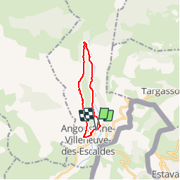
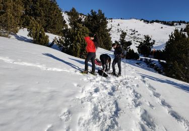
Tocht Sneeuwschoenen van 9,1 km beschikbaar op Occitanië, Pyrénées-Orientales, Angoustrine-Villeneuve-des-Escaldes. Deze tocht wordt voorgesteld door tracegps.
Beschrijving
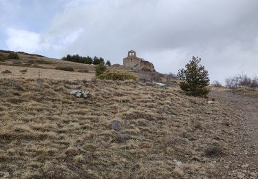
Une randonnée raquette pour monter à la chapelle Sant Marti d'Envalls en boucle depuis Angoustrine.
Plaatsbepaling
Land:
France
Regio :
Occitanië
Departement/Provincie :
Pyrénées-Orientales
Gemeente :
Angoustrine-Villeneuve-des-Escaldes
Locatie:
Unknown
Vertrek:(Dec)
Vertrek:(UTM)
414648 ; 4704105 (31T) N.
Opmerkingen
Wandeltochten in de omgeving
![Tocht Stappen Ur - de Ur vers La Chapelle de Belloc - Photo](https://media.geolcdn.com/t/375/260/ext.jpg?maxdim=2&url=https%3A%2F%2Fservices.sitytrail.com%2FGeolivesWS%2FDownloadMedia.ashx%3FTrailID%3D661447%26Media%3D20161117163202.jpg)
![Stappen Stappen](https://static1.geolcdn.com/sitytour/trail-icons/101.png)
de Ur vers La Chapelle de Belloc
Stappen
Gemakkelijk
(1)
Ur,
Occitanië,
Pyrénées-Orientales,
France
![](/images/other/stat-length.png)
20 km | 28 km-effort
7h 14min
![](https://static1.geolcdn.com/siteimages/upload/files/16400158638029165_repeat_loop_refresh_sync_direction_icon.png)
Ja
![Tocht Stappen Égat - Egat Puig Moro - Photo](https://media.geolcdn.com/t/375/260/ext.jpg?maxdim=2&url=https%3A%2F%2Fservices.sitytrail.com%2FGeolivesWS%2FDownloadMedia.ashx%3FTrailID%3D460362%26Media%3Dfix__20150817141649.jpg)
![Stappen Stappen](https://static1.geolcdn.com/sitytour/trail-icons/101.png)
Egat Puig Moro
Stappen
Medium
(1)
Égat,
Occitanië,
Pyrénées-Orientales,
France
![](/images/other/stat-length.png)
13,4 km | 19,3 km-effort
4h 51min
![](https://static1.geolcdn.com/siteimages/upload/files/16400158638029165_repeat_loop_refresh_sync_direction_icon.png)
Ja
![Tocht Stappen Égat - Le Pic dels Moros - Photo](https://media.geolcdn.com/t/375/260/ext.jpg?maxdim=2&url=https%3A%2F%2Fservices.sitytrail.com%2FGeolivesWS%2FDownloadMedia.ashx%3FTrailID%3D108942%26Media%3D2804_1.jpg)
![Stappen Stappen](https://static1.geolcdn.com/sitytour/trail-icons/101.png)
Le Pic dels Moros
Stappen
Moeilijk
(2)
Égat,
Occitanië,
Pyrénées-Orientales,
France
![](/images/other/stat-length.png)
12,1 km | 18,8 km-effort
5h 30min
![](https://static1.geolcdn.com/siteimages/upload/files/16400158638029165_repeat_loop_refresh_sync_direction_icon.png)
Ja
![Tocht Stappen Estavar - 20220328 Estavar-Tartassonne(?) - Photo](https://media.geolcdn.com/t/375/260/ext.jpg?maxdim=2&url=https%3A%2F%2Fmedia.geolcdn.com%2Ff%2Fd3a84297-78f4-4823-a8d6-7ab122d863c3.jpg)
![Stappen Stappen](https://static1.geolcdn.com/sitytour/trail-icons/101.png)
20220328 Estavar-Tartassonne(?)
Stappen
Medium
Estavar,
Occitanië,
Pyrénées-Orientales,
France
![](/images/other/stat-length.png)
14,8 km | 22 km-effort
3h 16min
![](https://static1.geolcdn.com/siteimages/upload/files/16400158638029165_repeat_loop_refresh_sync_direction_icon.png)
Ja
![Tocht Sneeuwschoenen Dorres - 2021-02-10 Sortie CAF - Port de Maurà depuis Dorres - Photo](https://media.geolcdn.com/t/375/260/ext.jpg?maxdim=2&url=https%3A%2F%2Fmedia.geolcdn.com%2Ff%2F20c0d1be-0c7b-47d9-997c-a6edaf439ba7.JPG)
![Sneeuwschoenen Sneeuwschoenen](https://static1.geolcdn.com/sitytour/trail-icons/504.png)
2021-02-10 Sortie CAF - Port de Maurà depuis Dorres
Sneeuwschoenen
Moeilijk
Dorres,
Occitanië,
Pyrénées-Orientales,
France
![](/images/other/stat-length.png)
17,9 km | 31 km-effort
9h 0min
![](https://static1.geolcdn.com/siteimages/upload/files/16400158638029165_repeat_loop_refresh_sync_direction_icon.png)
Ja
![Tocht Stappen Dorres - 2021-02-09 Sortie CAF - Dorres - Chapelle de Belloc - Dolmen de Brangoli - Photo](https://media.geolcdn.com/t/375/260/ext.jpg?maxdim=2&url=https%3A%2F%2Fmedia.geolcdn.com%2Ff%2F017e4484-f8d3-4e2b-ac2e-6d6ae6f514f4.JPG)
![Stappen Stappen](https://static1.geolcdn.com/sitytour/trail-icons/101.png)
2021-02-09 Sortie CAF - Dorres - Chapelle de Belloc - Dolmen de Brangoli
Stappen
Gemakkelijk
Dorres,
Occitanië,
Pyrénées-Orientales,
France
![](/images/other/stat-length.png)
13 km | 19,3 km-effort
5h 0min
![](https://static1.geolcdn.com/siteimages/upload/files/16400158638029165_repeat_loop_refresh_sync_direction_icon.png)
Ja
![Tocht Sneeuwschoenen Font-Romeu-Odeillo-Via - Autour du refuge de La Calme - Photo](https://media.geolcdn.com/t/375/260/ext.jpg?maxdim=2&url=https%3A%2F%2Fmedia.geolcdn.com%2Ff%2F86653a1e-fa66-4e42-b31c-19cd5980e9f8.jpg)
![Sneeuwschoenen Sneeuwschoenen](https://static1.geolcdn.com/sitytour/trail-icons/504.png)
Autour du refuge de La Calme
Sneeuwschoenen
Gemakkelijk
Font-Romeu-Odeillo-Via,
Occitanië,
Pyrénées-Orientales,
France
![](/images/other/stat-length.png)
15,5 km | 19,6 km-effort
4h 4min
![](https://static1.geolcdn.com/siteimages/upload/files/16400158638029165_repeat_loop_refresh_sync_direction_icon.png)
Neen
![Tocht Stappen Dorres - d'ores 2 - Photo](https://media.geolcdn.com/t/375/260/ext.jpg?maxdim=2&url=https%3A%2F%2Fmedia.geolcdn.com%2Ff%2F8d443e8b-e448-46c9-8d35-e5b2b8654ee9.jpg)
![Stappen Stappen](https://static1.geolcdn.com/sitytour/trail-icons/101.png)
d'ores 2
Stappen
Medium
Dorres,
Occitanië,
Pyrénées-Orientales,
France
![](/images/other/stat-length.png)
7,7 km | 11,1 km-effort
2h 46min
![](https://static1.geolcdn.com/siteimages/upload/files/16400158638029165_repeat_loop_refresh_sync_direction_icon.png)
Ja
![Tocht Stappen Dorres - Le chemin du Belloc - Photo](https://media.geolcdn.com/t/375/260/ext.jpg?maxdim=2&url=https%3A%2F%2Fmedia.geolcdn.com%2Ff%2Fbaea90ac-684a-4947-b800-0eea24315e65.jpg)
![Stappen Stappen](https://static1.geolcdn.com/sitytour/trail-icons/101.png)
Le chemin du Belloc
Stappen
Dorres,
Occitanië,
Pyrénées-Orientales,
France
![](/images/other/stat-length.png)
5,6 km | 8,9 km-effort
1h 44min
![](https://static1.geolcdn.com/siteimages/upload/files/16400158638029165_repeat_loop_refresh_sync_direction_icon.png)
Neen