


25 MARS 2019

FLOCON
Gebruiker
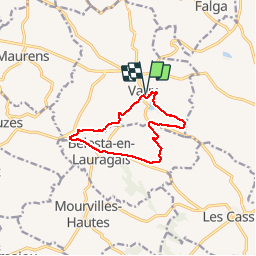

Lengte
10,4 km

Max. hoogte
297 m

Positief hoogteverschil
196 m
Km-Effort
13 km

Min. hoogte
214 m

Negatief hoogteverschil
197 m
Boucle
Ja
Datum van aanmaak :
2019-05-06 23:16:27.381
Laatste wijziging :
2019-05-06 23:16:27.381
2h32
Moeilijkheid : Medium

Gratisgps-wandelapplicatie
 SityTrail
IGN / Geografische instituten
SityTrail Plus
De wereld gaat voor u open
Over ons
Tocht Stappen van 10,4 km beschikbaar op Occitanië, Haute-Garonne, Vaux. Deze tocht wordt voorgesteld door FLOCON.
Beschrijving
LE VAUX
Plaatsbepaling
Land:
France
Regio :
Occitanië
Departement/Provincie :
Haute-Garonne
Gemeente :
Vaux
Locatie:
Unknown
Vertrek:(Dec)
Vertrek:(UTM)
405948 ; 4812126 (31T) N.
Opmerkingen