


fontaine l'abbé 2 à l'envers

werth
Gebruiker
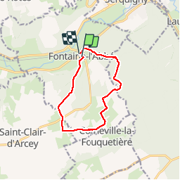

Lengte
9,6 km

Max. hoogte
165 m

Positief hoogteverschil
141 m
Km-Effort
11,5 km

Min. hoogte
85 m

Negatief hoogteverschil
146 m
Boucle
Ja
Datum van aanmaak :
2019-05-06 23:21:37.995
Laatste wijziging :
2019-05-06 23:21:37.995
2h29
Moeilijkheid : Gemakkelijk

Gratisgps-wandelapplicatie
 SityTrail
IGN / Geografische instituten
SityTrail Plus
De wereld gaat voor u open
Over ons
Tocht Stappen van 9,6 km beschikbaar op Normandië, Eure, Fontaine-l'Abbé. Deze tocht wordt voorgesteld door werth.
Plaatsbepaling
Land:
France
Regio :
Normandië
Departement/Provincie :
Eure
Gemeente :
Fontaine-l'Abbé
Locatie:
Unknown
Vertrek:(Dec)
Vertrek:(UTM)
331566 ; 5440134 (31U) N.
Opmerkingen