


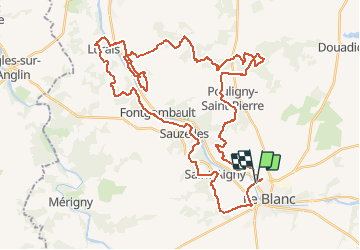
Zevtt - Le Blanc 2010

kipoura
Gebruiker

Lengte
52 km

Max. hoogte
140 m

Positief hoogteverschil
674 m
Km-Effort
61 km

Min. hoogte
67 m

Negatief hoogteverschil
675 m
Boucle
Ja
Datum van aanmaak :
2019-05-03 17:11:28.608
Laatste wijziging :
2019-05-03 17:11:28.701
4h00
Moeilijkheid : Medium

Gratisgps-wandelapplicatie
 SityTrail
IGN / Geografische instituten
SityTrail Plus
De wereld gaat voor u open
Over ons
Tocht Mountainbike van 52 km beschikbaar op Centre-Val de Loire, Indre, Le Blanc. Deze tocht wordt voorgesteld door kipoura.
Beschrijving
Une boucle VTT au départ de Le Blanc .... http://zevtt.free.fr
Plaatsbepaling
Land:
France
Regio :
Centre-Val de Loire
Departement/Provincie :
Indre
Gemeente :
Le Blanc
Locatie:
Unknown
Vertrek:(Dec)
Vertrek:(UTM)
351045 ; 5167042 (31T) N.
Opmerkingen