


Zevtt - St Guilhem le Désert

kipoura
Gebruiker

Lengte
40 km

Max. hoogte
836 m

Positief hoogteverschil
1450 m
Km-Effort
59 km

Min. hoogte
108 m

Negatief hoogteverschil
1458 m
Boucle
Ja
Datum van aanmaak :
2019-05-03 17:11:26.355
Laatste wijziging :
2019-05-03 17:11:26.397
4h00
Moeilijkheid : Moeilijk

Gratisgps-wandelapplicatie
 SityTrail
IGN / Geografische instituten
SityTrail Plus
De wereld gaat voor u open
Over ons
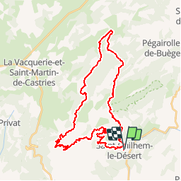
Tocht Mountainbike van 40 km beschikbaar op Occitanië, Hérault, Saint-Guilhem-le-Désert. Deze tocht wordt voorgesteld door kipoura.
Beschrijving
Une boucle VTT St Guilhem - St Guilhem, parcours splendide du pur bonheur .... http://zevtt.free.fr
Plaatsbepaling
Land:
France
Regio :
Occitanië
Departement/Provincie :
Hérault
Gemeente :
Saint-Guilhem-le-Désert
Locatie:
Unknown
Vertrek:(Dec)
Vertrek:(UTM)
544196 ; 4842568 (31T) N.
Opmerkingen