


baisy thy

ochelen
Gebruiker
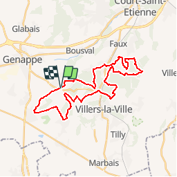

Lengte
29 km

Max. hoogte
164 m

Positief hoogteverschil
526 m
Km-Effort
36 km

Min. hoogte
78 m

Negatief hoogteverschil
527 m
Boucle
Ja
Datum van aanmaak :
2019-05-06 23:54:24.69
Laatste wijziging :
2019-05-06 23:54:24.69
4h31
Moeilijkheid : Onbekend

Gratisgps-wandelapplicatie
 SityTrail
IGN / Geografische instituten
SityTrail Plus
De wereld gaat voor u open
Over ons
Tocht Paard van 29 km beschikbaar op Wallonië, Waals-Brabant, Genepiën. Deze tocht wordt voorgesteld door ochelen.
Plaatsbepaling
Land:
Belgium
Regio :
Wallonië
Departement/Provincie :
Waals-Brabant
Gemeente :
Genepiën
Locatie:
Baisy-Thy
Vertrek:(Dec)
Vertrek:(UTM)
605469 ; 5605566 (31U) N.
Opmerkingen