


grosiboutjpb

jpb1309
Gebruiker
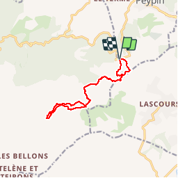

Lengte
12,7 km

Max. hoogte
689 m

Positief hoogteverschil
442 m
Km-Effort
18,6 km

Min. hoogte
420 m

Negatief hoogteverschil
436 m
Boucle
Ja
Datum van aanmaak :
2019-05-07 00:03:37.94
Laatste wijziging :
2019-05-07 00:03:37.94
4h57
Moeilijkheid : Onbekend

Gratisgps-wandelapplicatie
 SityTrail
IGN / Geografische instituten
SityTrail Plus
De wereld gaat voor u open
Over ons
Tocht Andere activiteiten van 12,7 km beschikbaar op Provence-Alpes-Côte d'Azur, Bouches-du-Rhône, Peypin. Deze tocht wordt voorgesteld door jpb1309.
Plaatsbepaling
Land:
France
Regio :
Provence-Alpes-Côte d'Azur
Departement/Provincie :
Bouches-du-Rhône
Gemeente :
Peypin
Locatie:
Unknown
Vertrek:(Dec)
Vertrek:(UTM)
707666 ; 4804225 (31T) N.
Opmerkingen