


Zevtt - Poitiers Sud Est

kipoura
Gebruiker
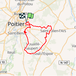

Lengte
49 km

Max. hoogte
146 m

Positief hoogteverschil
464 m
Km-Effort
55 km

Min. hoogte
100 m

Negatief hoogteverschil
464 m
Boucle
Ja
Datum van aanmaak :
2019-05-03 17:10:56.227
Laatste wijziging :
2019-05-03 17:10:56.306
2h30
Moeilijkheid : Gemakkelijk

Gratisgps-wandelapplicatie
 SityTrail
IGN / Geografische instituten
SityTrail Plus
De wereld gaat voor u open
Over ons
Tocht Mountainbike van 49 km beschikbaar op Nieuw-Aquitanië, Vienne, Poitiers. Deze tocht wordt voorgesteld door kipoura.
Beschrijving
Une petite escapade au Sud-est de Poitiers .... http://zevtt.free.fr
Plaatsbepaling
Land:
France
Regio :
Nieuw-Aquitanië
Departement/Provincie :
Vienne
Gemeente :
Poitiers
Locatie:
Unknown
Vertrek:(Dec)
Vertrek:(UTM)
299575 ; 5162354 (31T) N.
Opmerkingen