


Zevtt - St Benoît 2

kipoura
Gebruiker

Lengte
44 km

Max. hoogte
145 m

Positief hoogteverschil
638 m
Km-Effort
52 km

Min. hoogte
73 m

Negatief hoogteverschil
639 m
Boucle
Ja
Datum van aanmaak :
2019-05-03 17:10:53.247
Laatste wijziging :
2019-05-03 17:10:53.289
3h00
Moeilijkheid : Medium

Gratisgps-wandelapplicatie
 SityTrail
IGN / Geografische instituten
SityTrail Plus
De wereld gaat voor u open
Over ons
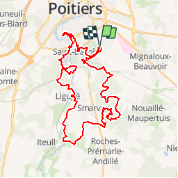
Tocht Mountainbike van 44 km beschikbaar op Nieuw-Aquitanië, Vienne, Saint-Benoît. Deze tocht wordt voorgesteld door kipoura.
Beschrijving
Allez encore un petit tour de VTT sur St Benoît juste par gourmandise.... http://zevtt.free.fr
Plaatsbepaling
Land:
France
Regio :
Nieuw-Aquitanië
Departement/Provincie :
Vienne
Gemeente :
Saint-Benoît
Locatie:
Unknown
Vertrek:(Dec)
Vertrek:(UTM)
297993 ; 5158906 (31T) N.
Opmerkingen