


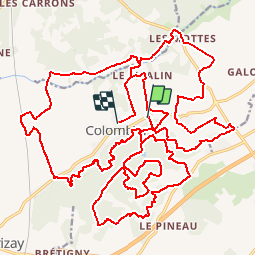
Zevtt - Colombiers 2007

kipoura
Gebruiker

Lengte
41 km

Max. hoogte
156 m

Positief hoogteverschil
510 m
Km-Effort
48 km

Min. hoogte
57 m

Negatief hoogteverschil
536 m
Boucle
Neen
Datum van aanmaak :
2019-05-03 17:10:51.805
Laatste wijziging :
2019-05-03 17:10:51.897
2h30
Moeilijkheid : Medium

Gratisgps-wandelapplicatie
 SityTrail
IGN / Geografische instituten
SityTrail Plus
De wereld gaat voor u open
Over ons
Tocht Mountainbike van 41 km beschikbaar op Nieuw-Aquitanië, Vienne, Colombiers. Deze tocht wordt voorgesteld door kipoura.
Beschrijving
Colombiers et sa forêt tout ce qu'il faut pour une sortie VTT réussite .... http://zevtt.free.fr
Plaatsbepaling
Land:
France
Regio :
Nieuw-Aquitanië
Departement/Provincie :
Vienne
Gemeente :
Colombiers
Locatie:
Unknown
Vertrek:(Dec)
Vertrek:(UTM)
304181 ; 5183391 (31T) N.
Opmerkingen