


comtes d'evreux

thle
Gebruiker
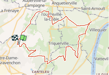

Lengte
24 km

Max. hoogte
146 m

Positief hoogteverschil
373 m
Km-Effort
29 km

Min. hoogte
38 m

Negatief hoogteverschil
373 m
Boucle
Ja
Datum van aanmaak :
2019-05-07 00:49:55.596
Laatste wijziging :
2019-05-21 08:34:44.979
--
Moeilijkheid : Onbekend

Gratisgps-wandelapplicatie
 SityTrail
IGN / Geografische instituten
SityTrail Plus
De wereld gaat voor u open
Over ons
Tocht Paard van 24 km beschikbaar op Normandië, Seine-Maritime, Port-Jérôme-sur-Seine. Deze tocht wordt voorgesteld door thle.


Plaatsbepaling
Land:
France
Regio :
Normandië
Departement/Provincie :
Seine-Maritime
Gemeente :
Port-Jérôme-sur-Seine
Locatie:
Notre-Dame-de-Gravenchon
Vertrek:(Dec)
Vertrek:(UTM)
325022 ; 5486028 (31U) N.
Opmerkingen
Beau circuit