


Andorre soldeu

labarone
Gebruiker
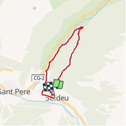

Lengte
5,7 km

Max. hoogte
2008 m

Positief hoogteverschil
250 m
Km-Effort
9,1 km

Min. hoogte
1753 m

Negatief hoogteverschil
255 m
Boucle
Ja
Datum van aanmaak :
2019-05-07 02:04:32.261
Laatste wijziging :
2019-05-07 02:04:32.261
2h00
Moeilijkheid : Gemakkelijk

Gratisgps-wandelapplicatie
 SityTrail
IGN / Geografische instituten
SityTrail Plus
De wereld gaat voor u open
Over ons
Tocht Stappen van 5,7 km beschikbaar op Andorra. Deze tocht wordt voorgesteld door labarone.
Beschrijving
Petite ballade
Il y a des cepes
Plaatsbepaling
Land:
Andorra
Regio :
Unknown
Departement/Provincie :
Unknown
Gemeente :
Unknown
Locatie:
Unknown
Vertrek:(Dec)
Vertrek:(UTM)
390553 ; 4714773 (31T) N.
Opmerkingen