


sacre trail des collines 2012

trailer38
Gebruiker
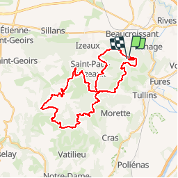

Lengte
35 km

Max. hoogte
783 m

Positief hoogteverschil
1646 m
Km-Effort
57 km

Min. hoogte
489 m

Negatief hoogteverschil
1662 m
Boucle
Ja
Datum van aanmaak :
2014-12-10 00:00:00.0
Laatste wijziging :
2014-12-10 00:00:00.0
--
Moeilijkheid : Moeilijk

Gratisgps-wandelapplicatie
 SityTrail
IGN / Geografische instituten
SityTrail Plus
De wereld gaat voor u open
Over ons
Tocht Lopen van 35 km beschikbaar op Auvergne-Rhône-Alpes, Isère, Beaucroissant. Deze tocht wordt voorgesteld door trailer38.
Beschrijving
37km 1500m


Plaatsbepaling
Land:
France
Regio :
Auvergne-Rhône-Alpes
Departement/Provincie :
Isère
Gemeente :
Beaucroissant
Locatie:
Unknown
Vertrek:(Dec)
Vertrek:(UTM)
693328 ; 5021863 (31T) N.
Opmerkingen