


Parcours footing 5

yannick-p
Gebruiker

Lengte
7,7 km

Max. hoogte
198 m

Positief hoogteverschil
62 m
Km-Effort
8,6 km

Min. hoogte
170 m

Negatief hoogteverschil
62 m
Boucle
Ja
Datum van aanmaak :
2014-12-10 00:00:00.0
Laatste wijziging :
2014-12-10 00:00:00.0
--
Moeilijkheid : Gemakkelijk

Gratisgps-wandelapplicatie
 SityTrail
IGN / Geografische instituten
SityTrail Plus
De wereld gaat voor u open
Over ons
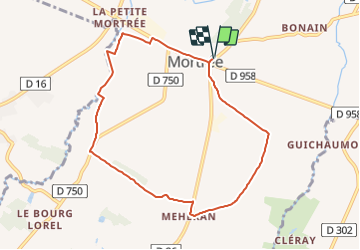
Tocht Lopen van 7,7 km beschikbaar op Normandië, Orne, Mortrée. Deze tocht wordt voorgesteld door yannick-p.
Plaatsbepaling
Land:
France
Regio :
Normandië
Departement/Provincie :
Orne
Gemeente :
Mortrée
Locatie:
Mortrée
Vertrek:(Dec)
Vertrek:(UTM)
284970 ; 5391519 (31U) N.
Opmerkingen