


Zevtt - Grand Poitiers 2012

kipoura
Gebruiker
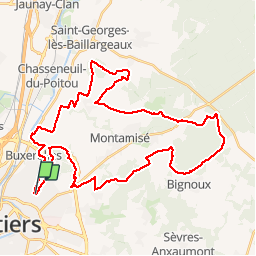

Lengte
44 km

Max. hoogte
136 m

Positief hoogteverschil
490 m
Km-Effort
51 km

Min. hoogte
69 m

Negatief hoogteverschil
492 m
Boucle
Ja
Datum van aanmaak :
2019-05-03 17:10:39.037
Laatste wijziging :
2019-05-03 17:10:39.099
2h00
Moeilijkheid : Gemakkelijk

Gratisgps-wandelapplicatie
 SityTrail
IGN / Geografische instituten
SityTrail Plus
De wereld gaat voor u open
Over ons
Tocht Mountainbike van 44 km beschikbaar op Nieuw-Aquitanië, Vienne, Buxerolles. Deze tocht wordt voorgesteld door kipoura.
Beschrijving
La trace de la Randonnée VTT de Grand Poitiers 2012 au départ de la Pépinière à Buxerolles ... http://zevtt.free.fr
Plaatsbepaling
Land:
France
Regio :
Nieuw-Aquitanië
Departement/Provincie :
Vienne
Gemeente :
Buxerolles
Locatie:
Unknown
Vertrek:(Dec)
Vertrek:(UTM)
298090 ; 5163501 (31T) N.
Opmerkingen