


Trail des Lucioles

trailer.nono
Gebruiker
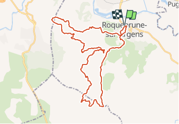

Lengte
24 km

Max. hoogte
402 m

Positief hoogteverschil
714 m
Km-Effort
33 km

Min. hoogte
16 m

Negatief hoogteverschil
715 m
Boucle
Ja
Datum van aanmaak :
2014-12-10 00:00:00.0
Laatste wijziging :
2014-12-10 00:00:00.0
2h36
Moeilijkheid : Gemakkelijk

Gratisgps-wandelapplicatie
 SityTrail
IGN / Geografische instituten
SityTrail Plus
De wereld gaat voor u open
Over ons
Tocht Lopen van 24 km beschikbaar op Provence-Alpes-Côte d'Azur, Var, Roquebrune-sur-Argens. Deze tocht wordt voorgesteld door trailer.nono.
Beschrijving
Course Roquebrune 24 Kms
Plaatsbepaling
Land:
France
Regio :
Provence-Alpes-Côte d'Azur
Departement/Provincie :
Var
Gemeente :
Roquebrune-sur-Argens
Locatie:
Unknown
Vertrek:(Dec)
Vertrek:(UTM)
308750 ; 4812920 (32T) N.
Opmerkingen