


Herbiester

SERGIO110_1
Gebruiker
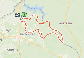

Lengte
16,8 km

Max. hoogte
439 m

Positief hoogteverschil
327 m
Km-Effort
21 km

Min. hoogte
310 m

Negatief hoogteverschil
325 m
Boucle
Ja
Datum van aanmaak :
2014-12-10 00:00:00.0
Laatste wijziging :
2014-12-10 00:00:00.0
2h47
Moeilijkheid : Medium

Gratisgps-wandelapplicatie
 SityTrail
IGN / Geografische instituten
SityTrail Plus
De wereld gaat voor u open
Over ons
Tocht Lopen van 16,8 km beschikbaar op Wallonië, Luik, Jalhay. Deze tocht wordt voorgesteld door SERGIO110_1.
Plaatsbepaling
Land:
Belgium
Regio :
Wallonië
Departement/Provincie :
Luik
Gemeente :
Jalhay
Locatie:
Jalhay
Vertrek:(Dec)
Vertrek:(UTM)
710201 ; 5606744 (31U) N.
Opmerkingen