Tocht Stappen Noisy-sur-École - 3Pi-120724 - 21 bosses - Photo
 randodan
randodan

Gebruiker

© OpenStreetMap contributors
Lengte
Lengte
15,6 km
Max. hoogte
Max. hoogte
122 m
Positief hoogteverschil
361 m
Km-Effort
Km-Effort  
20 km
Min. hoogte
Min. hoogte
71 m
Negatief hoogteverschil
361 m
Boucle
Boucle
Ja
Datum van aanmaak :
2014-12-10 00:00:00.0
Laatste wijziging :
2014-12-10 00:00:00.0

(0 Bericht)

Stappen
Stappen
8h01
Moeilijkheid : Moeilijk

Scan deze QR-code om de tocht te openen in de SityTrail-applicatie

Gratisgps-wandelapplicatie

Logo SityTrail SityTrail

IGN / Geografische instituten

SityTrail uit de App Store downloaden SityTrail uit Google Play downloaden

Logo SityTrail SityTrail Plus

De wereld gaat voor u open

SityTrail uit de App Store downloaden SityTrail uit Google Play downloaden SityTrail op Huawei AppGallery downloaden

Over ons

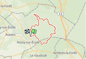
Tocht Stappen van 15,6 km beschikbaar op Île-de-France, Seine-et-Marne, Noisy-sur-École. Deze tocht wordt voorgesteld door randodan.

Beschrijving

Mardi 24 juillet 2012
Départ Noisy 7h40, 11°C !!
Cc faille après le "Caniche" .  
Ap.m. fait très chaud ~28° .
Mi quitte 25b au Ch.Melun-Vaudoué et attend 1h cote 73 .
Je quitte après Potala mais fais les Sabots .  
JC Lo font tout sauf Cailleau-Martin (23 bosses) .  
Retour 16h50, 17h15, 17h??
Mi Lo JC Da .
nota : le dénivelé automatique Geolives est faux => 21 bosses = ~ 700 m !

Hoogteprofiel

Foto's

POI's

POI Noisy-sur-École - Pique-nique - Photo
randodan
NOISY-SUR-ÉCOLE 
POI Noisy-sur-École - L'équipe sur le Guetteur - Photo
randodan
NOISY-SUR-ÉCOLE 

Plaatsbepaling

Land:
France
Regio :
Île-de-France
Departement/Provincie :
Seine-et-Marne
Gemeente :
Noisy-sur-École
Locatie:
Unknown
Vertrek:(Dec)
Vertrek:(UTM)
463799 ; 5357898 (31U) N.


Sluiten
Mijn abonnementen