


rock et roule 2

eventstrail
Gebruiker
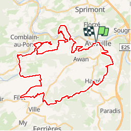

Lengte
48 km

Max. hoogte
366 m

Positief hoogteverschil
1208 m
Km-Effort
64 km

Min. hoogte
104 m

Negatief hoogteverschil
1208 m
Boucle
Ja
Datum van aanmaak :
2014-12-10 00:00:00.0
Laatste wijziging :
2014-12-10 00:00:00.0
--
Moeilijkheid : Onbekend

Gratisgps-wandelapplicatie
 SityTrail
IGN / Geografische instituten
SityTrail Plus
De wereld gaat voor u open
Over ons
Tocht Mountainbike van 48 km beschikbaar op Wallonië, Luik, Aywaille. Deze tocht wordt voorgesteld door eventstrail.


Plaatsbepaling
Land:
Belgium
Regio :
Wallonië
Departement/Provincie :
Luik
Gemeente :
Aywaille
Locatie:
Aywaille
Vertrek:(Dec)
Vertrek:(UTM)
689540 ; 5594705 (31U) N.
Opmerkingen