


Au Pays d'Azay-le-Rideau

leeho
Gebruiker
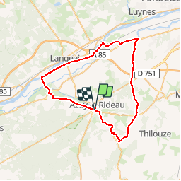

Lengte
53 km

Max. hoogte
110 m

Positief hoogteverschil
420 m
Km-Effort
58 km

Min. hoogte
34 m

Negatief hoogteverschil
420 m
Boucle
Neen
Datum van aanmaak :
2014-12-10 00:00:00.0
Laatste wijziging :
2014-12-10 00:00:00.0
2h40
Moeilijkheid : Gemakkelijk

Gratisgps-wandelapplicatie
 SityTrail
IGN / Geografische instituten
SityTrail Plus
De wereld gaat voor u open
Over ons
Tocht Fiets van 53 km beschikbaar op Centre-Val de Loire, Indre-et-Loire, Cheillé. Deze tocht wordt voorgesteld door leeho.
Beschrijving
Balade en les châteaux et la Loire
Plaatsbepaling
Land:
France
Regio :
Centre-Val de Loire
Departement/Provincie :
Indre-et-Loire
Gemeente :
Cheillé
Locatie:
Unknown
Vertrek:(Dec)
Vertrek:(UTM)
308176 ; 5237082 (31T) N.
Opmerkingen
