


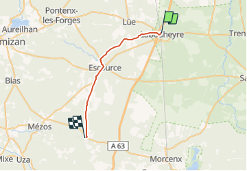
035 Labouheyre Onesse

lucille
Gebruiker

Lengte
26 km

Max. hoogte
81 m

Positief hoogteverschil
199 m
Km-Effort
28 km

Min. hoogte
44 m

Negatief hoogteverschil
223 m
Boucle
Neen
Datum van aanmaak :
2014-12-10 00:00:00.0
Laatste wijziging :
2014-12-10 00:00:00.0
6h11
Moeilijkheid : Onbekend

Gratisgps-wandelapplicatie
 SityTrail
IGN / Geografische instituten
SityTrail Plus
De wereld gaat voor u open
Over ons
Tocht Stappen van 26 km beschikbaar op Nieuw-Aquitanië, Landes, Labouheyre. Deze tocht wordt voorgesteld door lucille.
Beschrijving
Labouheyre / Onesse Laharie
Camping Le bienvenu
Plaatsbepaling
Land:
France
Regio :
Nieuw-Aquitanië
Departement/Provincie :
Landes
Gemeente :
Labouheyre
Locatie:
Unknown
Vertrek:(Dec)
Vertrek:(UTM)
666187 ; 4897753 (30T) N.
Opmerkingen