


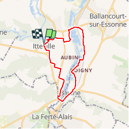
2012-12-05 Rando Itteville

jchezlemas
Gebruiker

Lengte
12 km

Max. hoogte
83 m

Positief hoogteverschil
90 m
Km-Effort
13,2 km

Min. hoogte
48 m

Negatief hoogteverschil
92 m
Boucle
Ja
Datum van aanmaak :
2014-12-10 00:00:00.0
Laatste wijziging :
2014-12-10 00:00:00.0
2h56
Moeilijkheid : Gemakkelijk

Gratisgps-wandelapplicatie
 SityTrail
IGN / Geografische instituten
SityTrail Plus
De wereld gaat voor u open
Over ons
Tocht Stappen van 12 km beschikbaar op Île-de-France, Essonne, Itteville. Deze tocht wordt voorgesteld door jchezlemas.
Plaatsbepaling
Land:
France
Regio :
Île-de-France
Departement/Provincie :
Essonne
Gemeente :
Itteville
Locatie:
Unknown
Vertrek:(Dec)
Vertrek:(UTM)
451415 ; 5373728 (31U) N.
Opmerkingen