


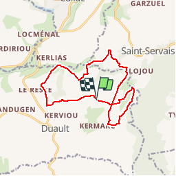
Duault - circuit des collines

FabienneD
Gebruiker

Lengte
14 km

Max. hoogte
220 m

Positief hoogteverschil
267 m
Km-Effort
17,6 km

Min. hoogte
128 m

Negatief hoogteverschil
270 m
Boucle
Ja
Datum van aanmaak :
2014-12-10 00:00:00.0
Laatste wijziging :
2014-12-10 00:00:00.0
3h46
Moeilijkheid : Medium

Gratisgps-wandelapplicatie
 SityTrail
IGN / Geografische instituten
SityTrail Plus
De wereld gaat voor u open
Over ons
Tocht Stappen van 14 km beschikbaar op Bretagne, Côtes-d'Armor, Duault. Deze tocht wordt voorgesteld door FabienneD.
Beschrijving
Duault - Circuit des collines
Description sur http://www.callac-argoat.fr/Randonnees,82
Balisage jaune

Plaatsbepaling
Land:
France
Regio :
Bretagne
Departement/Provincie :
Côtes-d'Armor
Gemeente :
Duault
Locatie:
Unknown
Vertrek:(Dec)
Vertrek:(UTM)
469340 ; 5357614 (30U) N.
Opmerkingen