


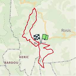
Caroux Table d'orientation Vialais Col de l'Ourtigas

jdelettrez
Gebruiker

Lengte
18 km

Max. hoogte
1090 m

Positief hoogteverschil
711 m
Km-Effort
27 km

Min. hoogte
753 m

Negatief hoogteverschil
713 m
Boucle
Ja
Datum van aanmaak :
2014-12-10 00:00:00.0
Laatste wijziging :
2014-12-10 00:00:00.0
5h39
Moeilijkheid : Moeilijk

Gratisgps-wandelapplicatie
 SityTrail
IGN / Geografische instituten
SityTrail Plus
De wereld gaat voor u open
Over ons
Tocht Stappen van 18 km beschikbaar op Occitanië, Hérault, Rosis. Deze tocht wordt voorgesteld door jdelettrez.
Beschrijving
De la table d'orientation au col de l'Ourtigas
Plaatsbepaling
Land:
France
Regio :
Occitanië
Departement/Provincie :
Hérault
Gemeente :
Rosis
Locatie:
Unknown
Vertrek:(Dec)
Vertrek:(UTM)
498025 ; 4828643 (31T) N.
Opmerkingen