


LA DEVEZE

CANON2
Gebruiker
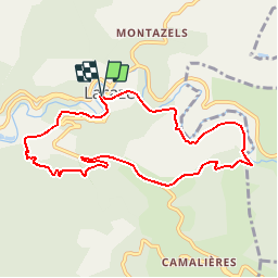

Lengte
9,1 km

Max. hoogte
712 m

Positief hoogteverschil
337 m
Km-Effort
13,7 km

Min. hoogte
468 m

Negatief hoogteverschil
341 m
Boucle
Ja
Datum van aanmaak :
2019-05-15 13:10:36.985
Laatste wijziging :
2019-05-15 13:10:37.021
2h56
Moeilijkheid : Gemakkelijk

Gratisgps-wandelapplicatie
 SityTrail
IGN / Geografische instituten
SityTrail Plus
De wereld gaat voor u open
Over ons
Tocht Stappen van 9,1 km beschikbaar op Occitanië, Tarn, Lacaze. Deze tocht wordt voorgesteld door CANON2.
Plaatsbepaling
Land:
France
Regio :
Occitanië
Departement/Provincie :
Tarn
Gemeente :
Lacaze
Locatie:
Unknown
Vertrek:(Dec)
Vertrek:(UTM)
461358 ; 4842788 (31T) N.
Opmerkingen