Tocht Stappen Saint-Chély-d'Apcher - De St Chely d'Apcher à Aumont  Aubrac - Photo

De St Chely d'Apcher à Aumont Aubrac

 tracegps
tracegps

Gebruiker

© OpenStreetMap contributors
Lengte
Lengte
18,6 km
Max. hoogte
Max. hoogte
1183 m
Positief hoogteverschil
438 m
Km-Effort
Km-Effort  
24 km
Min. hoogte
Min. hoogte
987 m
Negatief hoogteverschil
397 m
Boucle
Boucle
Neen
Datum van aanmaak :
2014-12-10 00:00:00.0
Laatste wijziging :
2014-12-10 00:00:00.0

(0 Bericht)

Stappen
Stappen
4h15
Moeilijkheid : Moeilijk

Scan deze QR-code om de tocht te openen in de SityTrail-applicatie

Gratisgps-wandelapplicatie

Logo SityTrail SityTrail

IGN / Geografische instituten

SityTrail uit de App Store downloaden SityTrail uit Google Play downloaden

Logo SityTrail SityTrail World

De wereld gaat voor u open

SityTrail uit de App Store downloaden SityTrail uit Google Play downloaden SityTrail op Huawei AppGallery downloaden

Over ons

Tocht Stappen van 18,6 km beschikbaar op Occitanië, Lozère, Saint-Chély-d'Apcher. Deze tocht wordt voorgesteld door tracegps.

Beschrijving

Départ place centrale. Joli parcours des Tours des Monts d'Aubrac dans une partie forestière.

Hoogteprofiel

Foto's

Plaatsbepaling

Land:
France
Regio :
Occitanië
Departement/Provincie :
Lozère
Gemeente :
Saint-Chély-d'Apcher
Locatie:
Unknown
Vertrek:(Dec)
Vertrek:(UTM)
521871 ; 4961196 (31T) N.

Wandeltochten in de omgeving

Tocht Moto-cross Saint-Chély-d'Apcher - saint-chely vimenet - Photo
Moto-cross
frank12

Moto-cross

Gemakkelijk
Saint-Chély-d'Apcher, Occitanië, Lozère, France
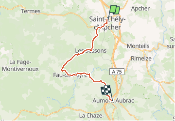
109 km | 149 km-effort
Onbekend
Neen
Tocht Stappen Saint-Chély-d'Apcher - Aubrac - 2° jour St Chély d'Apcher - Aumont Aubrac - Photo
Stappen
jmp76700

Stappen

Medium
Saint-Chély-d'Apcher, Occitanië, Lozère, France
18,1 km | 24 km-effort
5h 9min
Neen
Tocht Stappen Le Malzieu-Forain - Saint Pierre le Vieux - Photo
Stappen
tracegps

Stappen

Gemakkelijk
Le Malzieu-Forain, Occitanië, Lozère, France
6,3 km | 8,4 km-effort
1h 40min
Ja
Tocht Stappen Le Malzieu-Ville - Molières - Photo
Stappen
tracegps

Stappen

Gemakkelijk
Le Malzieu-Ville, Occitanië, Lozère, France
4,3 km | 6 km-effort
1h 0min
Ja
Tocht Motor Les Bessons - Parcours quad 02 - Photo
Motor
splanc

Motor

Moeilijk
Les Bessons, Occitanië, Lozère, France
17,5 km | 22 km-effort
56min
Ja
Tocht Motor Les Bessons - Tour QUAD 001 - Photo
Motor
splanc

Motor

Medium
Les Bessons, Occitanië, Lozère, France
16,2 km | 21 km-effort
Onbekend
Ja
Tocht Stappen Prunières - SityTrail - Apcher  la Tuyère - Photo
Stappen
raymondfn

Stappen

Moeilijk
Prunières, Occitanië, Lozère, France
11,6 km | 15,3 km-effort
3h 28min
Ja
Tocht Mountainbike Saint-Chély-d'Apcher - St chely d'apcher siniere  - Photo
Mountainbike
yvesdpt38

Mountainbike

Zeer moeilijk
Saint-Chély-d'Apcher, Occitanië, Lozère, France
38 km | 49 km-effort
3h 22min
Neen
Tocht Elektrische fiets Saint-Chély-d'Apcher - 3_250423 - Photo
Elektrische fiets
ricou1964

Elektrische fiets

Moeilijk
Saint-Chély-d'Apcher, Occitanië, Lozère, France
40 km | 52 km-effort
5h 22min
Neen


Sluiten
Mijn abonnementen