


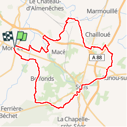
Mortrée - Sées - Mortrée

yannick-p
Gebruiker

Lengte
40 km

Max. hoogte
239 m

Positief hoogteverschil
304 m
Km-Effort
44 km

Min. hoogte
165 m

Negatief hoogteverschil
305 m
Boucle
Ja
Datum van aanmaak :
2014-12-10 00:00:00.0
Laatste wijziging :
2014-12-10 00:00:00.0
2h58
Moeilijkheid : Gemakkelijk

Gratisgps-wandelapplicatie
 SityTrail
IGN / Geografische instituten
SityTrail Plus
De wereld gaat voor u open
Over ons
Tocht Mountainbike van 40 km beschikbaar op Normandië, Orne, Mortrée. Deze tocht wordt voorgesteld door yannick-p.
Beschrijving
Petite balade VTT, parcours facile dans les chemins de plaine. Pas de difficulté particulière, un peu de route.
Plaatsbepaling
Land:
France
Regio :
Normandië
Departement/Provincie :
Orne
Gemeente :
Mortrée
Locatie:
Mortrée
Vertrek:(Dec)
Vertrek:(UTM)
284968 ; 5391536 (31U) N.
Opmerkingen