


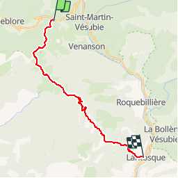
la colmiane lantosque

sylvainstaels
Gebruiker

Lengte
22 km

Max. hoogte
2020 m

Positief hoogteverschil
771 m
Km-Effort
35 km

Min. hoogte
508 m

Negatief hoogteverschil
1758 m
Boucle
Neen
Datum van aanmaak :
2014-12-10 00:00:00.0
Laatste wijziging :
2014-12-10 00:00:00.0
2h09
Moeilijkheid : Moeilijk

Gratisgps-wandelapplicatie
 SityTrail
IGN / Geografische instituten
SityTrail Plus
De wereld gaat voor u open
Over ons
Tocht Mountainbike van 22 km beschikbaar op Provence-Alpes-Côte d'Azur, Alpes-Maritimes, Valdeblore. Deze tocht wordt voorgesteld door sylvainstaels.
Plaatsbepaling
Land:
France
Regio :
Provence-Alpes-Côte d'Azur
Departement/Provincie :
Alpes-Maritimes
Gemeente :
Valdeblore
Locatie:
Unknown
Vertrek:(Dec)
Vertrek:(UTM)
357574 ; 4881290 (32T) N.
Opmerkingen