


Camp-comiac

albert318
Gebruiker
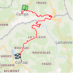

Lengte
13,4 km

Max. hoogte
564 m

Positief hoogteverschil
466 m
Km-Effort
19,8 km

Min. hoogte
267 m

Negatief hoogteverschil
517 m
Boucle
Neen
Datum van aanmaak :
2014-12-10 00:00:00.0
Laatste wijziging :
2014-12-10 00:00:00.0
2h37
Moeilijkheid : Medium

Gratisgps-wandelapplicatie
 SityTrail
IGN / Geografische instituten
SityTrail Plus
De wereld gaat voor u open
Over ons
Tocht Stappen van 13,4 km beschikbaar op Nieuw-Aquitanië, Corrèze, Camps-Saint-Mathurin-Léobazel. Deze tocht wordt voorgesteld door albert318.
Beschrijving
Via la salesse
Plaatsbepaling
Land:
France
Regio :
Nieuw-Aquitanië
Departement/Provincie :
Corrèze
Gemeente :
Camps-Saint-Mathurin-Léobazel
Locatie:
Unknown
Vertrek:(Dec)
Vertrek:(UTM)
420307 ; 4981564 (31T) N.
Opmerkingen