


Conches en Ouche

Laurent53
Gebruiker
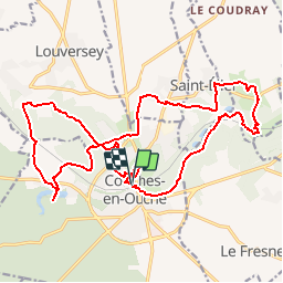

Lengte
21 km

Max. hoogte
160 m

Positief hoogteverschil
283 m
Km-Effort
25 km

Min. hoogte
97 m

Negatief hoogteverschil
288 m
Boucle
Ja
Datum van aanmaak :
2018-08-17 12:35:50.413
Laatste wijziging :
2018-08-20 07:44:56.505
--
Moeilijkheid : Gemakkelijk
5h27
Moeilijkheid : Gemakkelijk

Gratisgps-wandelapplicatie
 SityTrail
IGN / Geografische instituten
SityTrail Plus
De wereld gaat voor u open
Over ons
Tocht Te voet van 21 km beschikbaar op Normandië, Eure, Conches-en-Ouche. Deze tocht wordt voorgesteld door Laurent53.
Foto's


Plaatsbepaling
Land:
France
Regio :
Normandië
Departement/Provincie :
Eure
Gemeente :
Conches-en-Ouche
Locatie:
Unknown
Vertrek:(Dec)
Vertrek:(UTM)
349260 ; 5425400 (31U) N.
Opmerkingen