


2018-09-05_15h29m41_Lac Sans Fond et col de Forclaz

PhilippeC54
Gebruiker
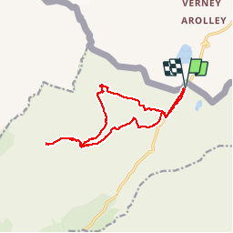

Lengte
14,3 km

Max. hoogte
2525 m

Positief hoogteverschil
604 m
Km-Effort
22 km

Min. hoogte
2120 m

Negatief hoogteverschil
603 m
Boucle
Ja
Datum van aanmaak :
2018-09-10 10:06:01.808
Laatste wijziging :
2018-09-10 10:10:17.024
4h37
Moeilijkheid : Zeer moeilijk

Gratisgps-wandelapplicatie
 SityTrail
IGN / Geografische instituten
SityTrail Plus
De wereld gaat voor u open
Over ons
Tocht Stappen van 14,3 km beschikbaar op Auvergne-Rhône-Alpes, Savoie, Séez. Deze tocht wordt voorgesteld door PhilippeC54.
Plaatsbepaling
Land:
France
Regio :
Auvergne-Rhône-Alpes
Departement/Provincie :
Savoie
Gemeente :
Séez
Locatie:
Unknown
Vertrek:(Dec)
Vertrek:(UTM)
335141 ; 5060601 (32T) N.
Opmerkingen