


Bois Belleville & Marbache

PhilippeC54
Gebruiker

Lengte
42 km

Max. hoogte
337 m

Positief hoogteverschil
542 m
Km-Effort
50 km

Min. hoogte
177 m

Negatief hoogteverschil
542 m
Boucle
Ja
Datum van aanmaak :
2018-09-23 06:00:24.252
Laatste wijziging :
2018-09-23 17:14:01.394
3h29
Moeilijkheid : Gemakkelijk

Gratisgps-wandelapplicatie
 SityTrail
IGN / Geografische instituten
SityTrail Plus
De wereld gaat voor u open
Over ons
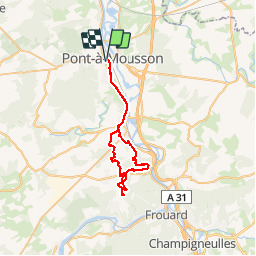
Tocht Mountainbike van 42 km beschikbaar op Grand Est, Meurthe-et-Moselle, Pont-à-Mousson. Deze tocht wordt voorgesteld door PhilippeC54.
Beschrijving
Le départ réel est depuis le parking du cimetière de Dieulouard
Plaatsbepaling
Land:
France
Regio :
Grand Est
Departement/Provincie :
Meurthe-et-Moselle
Gemeente :
Pont-à-Mousson
Locatie:
Unknown
Vertrek:(Dec)
Vertrek:(UTM)
283575 ; 5420441 (32U) N.
Opmerkingen