


La randonnée autour de Chazelles

alainjoseph6
Gebruiker

Lengte
9,6 km

Max. hoogte
131 m

Positief hoogteverschil
112 m
Km-Effort
11,1 km

Min. hoogte
88 m

Negatief hoogteverschil
112 m
Boucle
Ja
Datum van aanmaak :
2018-11-04 13:54:34.395
Laatste wijziging :
2018-11-04 16:28:27.489
2h32
Moeilijkheid : Gemakkelijk

Gratisgps-wandelapplicatie
 SityTrail
IGN / Geografische instituten
SityTrail Plus
De wereld gaat voor u open
Over ons
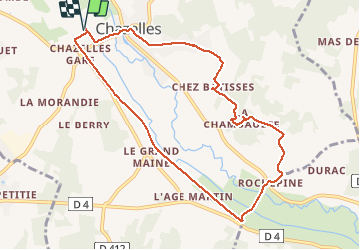
Tocht Stappen van 9,6 km beschikbaar op Nieuw-Aquitanië, Charente, Chazelles. Deze tocht wordt voorgesteld door alainjoseph6.
Beschrijving
Nous démarrons la randonnée après les terrains de football par la voie verte jusqu'à Rochepine. Le village de chez Bâtisse est sympa. Puis Chazelles.
Foto's


Plaatsbepaling
Land:
France
Regio :
Nieuw-Aquitanië
Departement/Provincie :
Charente
Gemeente :
Chazelles
Locatie:
Unknown
Vertrek:(Dec)
Vertrek:(UTM)
294264 ; 5058255 (31T) N.
Opmerkingen