


9305992-REC CTM 2018 technique

PhilippeC54
Gebruiker
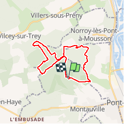

Lengte
13,6 km

Max. hoogte
383 m

Positief hoogteverschil
231 m
Km-Effort
16,7 km

Min. hoogte
298 m

Negatief hoogteverschil
234 m
Boucle
Ja
Datum van aanmaak :
2018-11-14 07:53:43.808
Laatste wijziging :
2018-11-14 07:59:14.298
--
Moeilijkheid : Medium

Gratisgps-wandelapplicatie
 SityTrail
IGN / Geografische instituten
SityTrail Plus
De wereld gaat voor u open
Over ons
Tocht Mountainbike van 13,6 km beschikbaar op Grand Est, Meurthe-et-Moselle, Montauville. Deze tocht wordt voorgesteld door PhilippeC54.
Plaatsbepaling
Land:
France
Regio :
Grand Est
Departement/Provincie :
Meurthe-et-Moselle
Gemeente :
Montauville
Locatie:
Unknown
Vertrek:(Dec)
Vertrek:(UTM)
280789 ; 5422193 (32U) N.
Opmerkingen