


Bois de Belleville et Pompey

PhilippeC54
Gebruiker
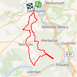

Lengte
30 km

Max. hoogte
360 m

Positief hoogteverschil
426 m
Km-Effort
36 km

Min. hoogte
195 m

Negatief hoogteverschil
422 m
Boucle
Neen
Datum van aanmaak :
2018-11-25 08:40:28.971
Laatste wijziging :
2018-11-28 17:47:28.003
2h48
Moeilijkheid : Heel gemakkelijk

Gratisgps-wandelapplicatie
 SityTrail
IGN / Geografische instituten
SityTrail Plus
De wereld gaat voor u open
Over ons
Tocht Mountainbike van 30 km beschikbaar op Grand Est, Meurthe-et-Moselle, Dieulouard. Deze tocht wordt voorgesteld door PhilippeC54.
Plaatsbepaling
Land:
France
Regio :
Grand Est
Departement/Provincie :
Meurthe-et-Moselle
Gemeente :
Dieulouard
Locatie:
Unknown
Vertrek:(Dec)
Vertrek:(UTM)
284588 ; 5413962 (32U) N.
Opmerkingen