


Chàumont sur Tharonne

lemuid
Gebruiker
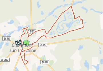

Lengte
11,3 km

Max. hoogte
148 m

Positief hoogteverschil
102 m
Km-Effort
12,7 km

Min. hoogte
118 m

Negatief hoogteverschil
102 m
Boucle
Ja
Datum van aanmaak :
2018-11-25 09:04:19.483
Laatste wijziging :
2018-11-25 17:03:20.93
2h34
Moeilijkheid : Heel gemakkelijk

Gratisgps-wandelapplicatie
 SityTrail
IGN / Geografische instituten
SityTrail Plus
De wereld gaat voor u open
Over ons
Tocht Stappen van 11,3 km beschikbaar op Centre-Val de Loire, Loir-et-Cher, Chaumont-sur-Tharonne. Deze tocht wordt voorgesteld door lemuid.
Plaatsbepaling
Land:
France
Regio :
Centre-Val de Loire
Departement/Provincie :
Loir-et-Cher
Gemeente :
Chaumont-sur-Tharonne
Locatie:
Unknown
Vertrek:(Dec)
Vertrek:(UTM)
417674 ; 5273585 (31T) N.
Opmerkingen