


SityTrail - Coquibus - 100 Marches

c.chehere
Gebruiker
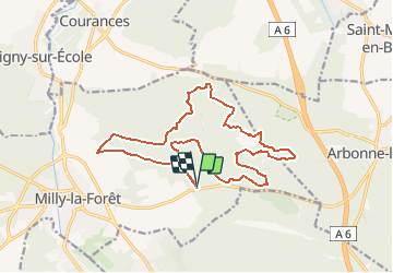

Lengte
17,5 km

Max. hoogte
136 m

Positief hoogteverschil
314 m
Km-Effort
22 km

Min. hoogte
70 m

Negatief hoogteverschil
313 m
Boucle
Ja
Datum van aanmaak :
2018-12-02 11:47:51.552
Laatste wijziging :
2020-03-06 16:53:46.29
4h49
Moeilijkheid : Medium

Gratisgps-wandelapplicatie
 SityTrail
IGN / Geografische instituten
SityTrail Plus
De wereld gaat voor u open
Over ons
Tocht Stappen van 17,5 km beschikbaar op Île-de-France, Essonne, Milly-la-Forêt. Deze tocht wordt voorgesteld door c.chehere.
Beschrijving
Parking sur la D837 près de l'auberge du Coquibus
Plaatsbepaling
Land:
France
Regio :
Île-de-France
Departement/Provincie :
Essonne
Gemeente :
Milly-la-Forêt
Locatie:
Unknown
Vertrek:(Dec)
Vertrek:(UTM)
463598 ; 5361444 (31U) N.
Opmerkingen