


SityTrail - ADAL_Jouars_16112016

c.chehere
Gebruiker
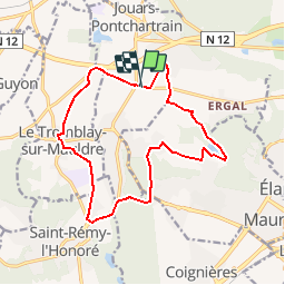

Lengte
14,4 km

Max. hoogte
177 m

Positief hoogteverschil
200 m
Km-Effort
17,1 km

Min. hoogte
72 m

Negatief hoogteverschil
202 m
Boucle
Ja
Datum van aanmaak :
2018-12-05 14:32:28.33
Laatste wijziging :
2018-12-05 14:39:45.678
3h43
Moeilijkheid : Medium

Gratisgps-wandelapplicatie
 SityTrail
IGN / Geografische instituten
SityTrail Plus
De wereld gaat voor u open
Over ons
Tocht Stappen van 14,4 km beschikbaar op Île-de-France, Yvelines, Jouars-Pontchartrain. Deze tocht wordt voorgesteld door c.chehere.
Plaatsbepaling
Land:
France
Regio :
Île-de-France
Departement/Provincie :
Yvelines
Gemeente :
Jouars-Pontchartrain
Locatie:
Unknown
Vertrek:(Dec)
Vertrek:(UTM)
419278 ; 5404585 (31U) N.
Opmerkingen