


Falaen juin 2013

gue
Gebruiker
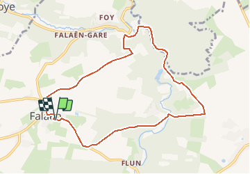

Lengte
8,4 km

Max. hoogte
231 m

Positief hoogteverschil
203 m
Km-Effort
11,1 km

Min. hoogte
127 m

Negatief hoogteverschil
204 m
Boucle
Ja
Datum van aanmaak :
2014-12-10 00:00:00.0
Laatste wijziging :
2014-12-10 00:00:00.0
2h21
Moeilijkheid : Onbekend

Gratisgps-wandelapplicatie
 SityTrail
IGN / Geografische instituten
SityTrail Plus
De wereld gaat voor u open
Over ons
Tocht Stappen van 8,4 km beschikbaar op Wallonië, Namen, Onhaye. Deze tocht wordt voorgesteld door gue.
Plaatsbepaling
Land:
Belgium
Regio :
Wallonië
Departement/Provincie :
Namen
Gemeente :
Onhaye
Locatie:
Falaën
Vertrek:(Dec)
Vertrek:(UTM)
627971 ; 5571037 (31U) N.
Opmerkingen