


S-J-IBOS/BARTRES

CANON2
Gebruiker

Lengte
19,3 km

Max. hoogte
551 m

Positief hoogteverschil
337 m
Km-Effort
23 km

Min. hoogte
314 m

Negatief hoogteverschil
164 m
Boucle
Neen
Datum van aanmaak :
2019-05-15 13:09:44.849
Laatste wijziging :
2019-05-15 13:09:45.269
5h06
Moeilijkheid : Gemakkelijk

Gratisgps-wandelapplicatie
 SityTrail
IGN / Geografische instituten
SityTrail Plus
De wereld gaat voor u open
Over ons
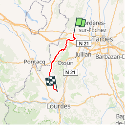
Tocht Stappen van 19,3 km beschikbaar op Occitanië, Hautes-Pyrénées, Ibos. Deze tocht wordt voorgesteld door CANON2.
Beschrijving
ferme Laurens
3, route d'Adé
65100, Bartrès
Contact
Tel : 05 62 42 34 96
Fax : 05 62 42 34 96
E-mail : ferme.laurens@wanadoo.fr
Plaatsbepaling
Land:
France
Regio :
Occitanië
Departement/Provincie :
Hautes-Pyrénées
Gemeente :
Ibos
Locatie:
Unknown
Vertrek:(Dec)
Vertrek:(UTM)
743366 ; 4792268 (30T) N.
Opmerkingen
Très bien