


arras hesdin

hagan
Gebruiker
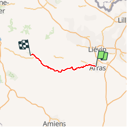

Lengte
73 km

Max. hoogte
154 m

Positief hoogteverschil
788 m
Km-Effort
83 km

Min. hoogte
25 m

Negatief hoogteverschil
821 m
Boucle
Neen
Datum van aanmaak :
2014-12-10 00:00:00.0
Laatste wijziging :
2014-12-10 00:00:00.0
30h00
Moeilijkheid : Medium

Gratisgps-wandelapplicatie
 SityTrail
IGN / Geografische instituten
SityTrail Plus
De wereld gaat voor u open
Over ons
Tocht Stappen van 73 km beschikbaar op Hauts-de-France, Pas-de-Calais, Sainte-Catherine. Deze tocht wordt voorgesteld door hagan.
Plaatsbepaling
Land:
France
Regio :
Hauts-de-France
Departement/Provincie :
Pas-de-Calais
Gemeente :
Sainte-Catherine
Locatie:
Unknown
Vertrek:(Dec)
Vertrek:(UTM)
482606 ; 5572193 (31U) N.
Opmerkingen
