


devant le pré

thomas1986
Gebruiker
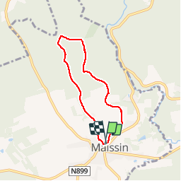

Lengte
5,1 km

Max. hoogte
411 m

Positief hoogteverschil
101 m
Km-Effort
6,5 km

Min. hoogte
354 m

Negatief hoogteverschil
106 m
Boucle
Ja
Datum van aanmaak :
2019-02-02 11:29:43.747
Laatste wijziging :
2019-02-02 12:39:55.229
1h09
Moeilijkheid : Heel gemakkelijk

Gratisgps-wandelapplicatie
 SityTrail
IGN / Geografische instituten
SityTrail Plus
De wereld gaat voor u open
Over ons
Tocht Stappen van 5,1 km beschikbaar op Wallonië, Luxemburg, Paliseul. Deze tocht wordt voorgesteld door thomas1986.
Foto's


Plaatsbepaling
Land:
Belgium
Regio :
Wallonië
Departement/Provincie :
Luxemburg
Gemeente :
Paliseul
Locatie:
Maissin
Vertrek:(Dec)
Vertrek:(UTM)
656296 ; 5537084 (31U) N.
Opmerkingen