


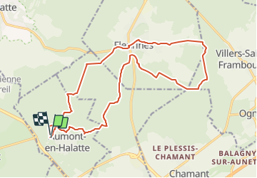
boucle 20km aumont en halatte

Glurps
Gebruiker

Lengte
19,8 km

Max. hoogte
183 m

Positief hoogteverschil
346 m
Km-Effort
24 km

Min. hoogte
97 m

Negatief hoogteverschil
336 m
Boucle
Ja
Datum van aanmaak :
2014-12-10 00:00:00.0
Laatste wijziging :
2014-12-10 00:00:00.0
5h14
Moeilijkheid : Medium

Gratisgps-wandelapplicatie
 SityTrail
IGN / Geografische instituten
SityTrail Plus
De wereld gaat voor u open
Over ons
Tocht Stappen van 19,8 km beschikbaar op Hauts-de-France, Oise, Aumont-en-Halatte. Deze tocht wordt voorgesteld door Glurps.
Plaatsbepaling
Land:
France
Regio :
Hauts-de-France
Departement/Provincie :
Oise
Gemeente :
Aumont-en-Halatte
Locatie:
Unknown
Vertrek:(Dec)
Vertrek:(UTM)
466968 ; 5453193 (31U) N.
Opmerkingen